PATH FOR ALL - Antigorio Valley/Formazza Valley/Alpe Devero
THE ITINERARY IS ACCESSIBLE FOR TOURISTS WITH SPECIFIC NEEDS (Project "FOR ALL Tourism for All All Tourists")
Minimum duration: 1 to 2 days
Difficulty of the route: Low
Length of the route in km: 35 km
LOCATION DESCRIPTION
The Antigorio Valley is entirely crossed by the Toce River and includes the municipalities of Crodo, Baceno and Premia. Continuing northwards we find the Val Formazza, with its famous Toce Waterfall, while from Baceno, proceeding north-west, we reach the Alpe Devero which is part of the Natural Park Alpe Veglia -Devero, an uncontaminated paradise for alpine vegetation and fauna, located in the heart of the Alps.
ANTIGORIO VALLEY
INFORMATION
TOURIST OFFICE
Loc. Bagni, 20, Crodo (VB) - tel +39 0324600005 - altaossola@gmail.com
MUNICIPALITY of Crodo
Tel. +39 032461003 - protocollo@comune.crodo.vb.it
MUNICIPALITY of Premia
Tel. +39 032462021 - protocollo@comune.premia.vb.it
WHAT TO SEE
There are two accessible routes in the Antigorio Valley.
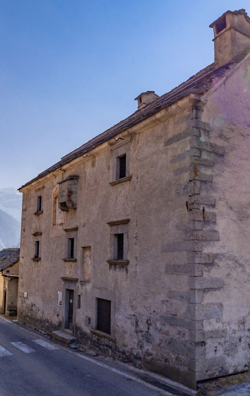
The first one is located in Verampio di Crodo, a path of about 3 km. You can leave your car at the sports field in Verampio, near the Ettore Conti power station (one of the oldest in Italy - year 1912) and then continue on a totally flat plain on an asphalt road, there are no particular slopes or uneven areas. On the way you can admire the power station, the flowing river and above all you are in the heart of the geological zone, called Element Zero, where the deepest tectonic element of the Alps emerges.
In Premia you can relax at the Thermal Baths in the outdoor and indoor pools and enjoy the wellness trail. The spa is equipped with an electric lift allowing people with disabilities to enter the water. In front of Premia Terme, going up on the left, there is a very interesting and totally flat route - Piana del piffero - immersed in the green of the mountains and meadows, from which it is possible to admire the waterfalls running from the mountains, typical alpine houses and a small chapel. The route is about 2 km long and is flat, asphalted and without any barriers. Continuing northwards, you enter Val Formazza.
FORMAZZA VALLEY
INFORMATION
TOURIST OFFICE
Fraz. Ponte, 4 - Formazza. Tel +39 0324 63059 - prolocoformazza@libero.it - www.valformazza.it
MUNICIPALITY of Formazza:
Tel +39 0324 63017 - municipio@comune.formazza.vb.it
WHAT TO SEE
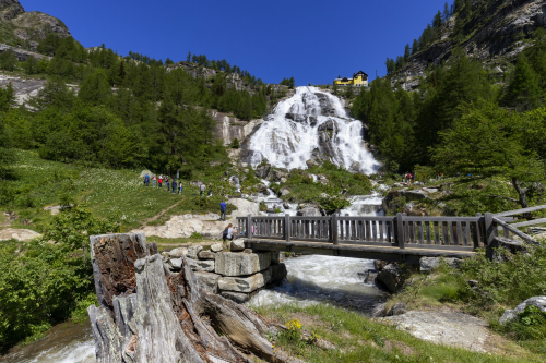
With a 143-metre drop, the imposing Toce Waterfall is the symbol of the Formazza Valley. The visit route Una Cascata per Tutti (A Waterfall for Everyone), thanks to its even ground and minimal gradient, allows anyone, even those with reduced mobility, to approach the base of the Falls and fully enjoy its beauty. The audio-guide panels that accompany the route convey the unforgettable impression that the Toce Falls left on illustrious travellers. Access to the route is at Sottofrua (20 metres before the tunnel on the left), where you can leave your car in the Casa Sottofrua car park. The initial part of the route currently has a significant gradient with cobblestones, sand and uneven pavement for about 50 metres before joining the accessible route. After admiring the waterfall, continue north until you reach Riale, thenorthernmost hamlet in Piedmont at 1730 m. It was one of the first Walser settlements to arrive from the neighbouring Valais through the Gries Pass and a real jewel of mountain architecture. It is located in a flat area and is therefore also accessible in winter. The asphalt road leads to the Morasco dam. The entire route is about 3 km, but the last section is recommended for cars only, as it is uphill. Once at the dam, it is possible to walk along the shore of Lake Morasco (at 1815 m) admiring the wonderful colours of the water.
ALPE DEVERO
INFORMATION
HOW TO GET THERE
By car from Domodossola, drive up the Valle Antigorio Formazza, and once in Baceno turn left to reach the Alpe Devero Park. Travel time is approximately 45/50 minutes (35 km).
PARKING
Vehicles with disabled people and in possession of a badge can park free of charge in the special parking areas in Balmavalle or Cologno. In addition, upon request to the municipal police, they can enter the Limited Traffic (ZTL) zone up to the Devero church, thus overcoming the initial climb from the parking area to the Devero plain which is rather steep. The car must then be brought back to the parking areas. If the driver is a disabled person, permission must be obtained from the municipal police to park for a few hours.
MUNICIPAL POLICE of Baceno:
Tel +39 0324 62018 - email: poliziamunicipale@comune.baceno.vb.it - pec (certified email) baceno@pec.it
WHAT TO SEE
From the church it is possible to move easily around along the Devero plain, also with a wheelchair, considering that the path is on beaten earth and/or grass. Crampiolo, a small alpine village half an hour's walk from Devero, can be accessed by electric minibuses run by private tour operators (info www.vividevero.it – info@vividevero.it)
OVERALL ACCESSIBILITY DESCRIPTION:
The routes are accessible for people with reduced mobility. For people who use a manual wheelchair it is advisable to have an accompanying person, especially at Devero where there may be places with steep slopes and broken sections. The other routes are totally accessible and usable even without an accompanying person, as they are flat and asphalted.
Path maker: Fabrizio Marta - Rotex
Author of texts: Fabrizio Marta - Rotex
46.376543618186, 8.4261703491211
46.376543618186, 8.4261703491211
Nearby
Discover places, experiences and activities in nearby locations


